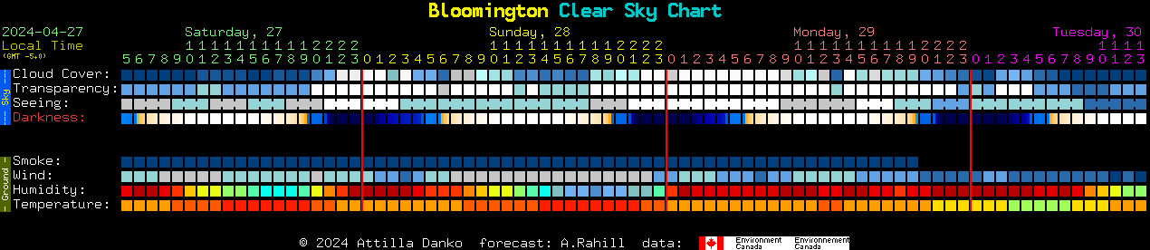
|
Updated: @
11-Jun-2021 12:31pm - next update at 12:00am
|
| Summary / Temperature |
Wind |
Rain |
Outlook |

|
Partly cloudy
|

|
91.0°F

Hot
Feels like:
96°F
24-hr difference
5°F |
| |
Today |
Yesterday |
| High: |
91.0°F
12:01pm |
89.1°F
2:01pm |
| Low: |
71.1°F
5:01am |
71.1°F
5:01am |
|
|


|
N
5.0
Gust:
5.0 mph
|
|
2 Bft -
Light Breeze
|
|
Today:
5.0 mph
9:01am
|
|
Gust Month: 28.0 mph
June 5
|
|
| Rain Today: |
0.00 in
|
| Rain Rate (/hr): |
0.000 in
|
| Rain Yesterday: |
0.00 in
|
| Storm Rain: |
0.00 in |
| This Month: |
0.69 in
|
| Season Total: |
16.25 in
|
|
1 rain day in June. |
|
Tonight

Mostly Cloudy |
|
| Humidity & Barometer |
Almanac |
Moon |
| Humidity: |
48 %
 |
| Dew Point: |
68.6°F
|
| Barometer: |
29.860 inHg
|
| Baro Trend: |
Steady
|
|
| Sunrise: |
12:56am |
| Sunset: |
1:03pm |
| Moonrise: |
1:38am |
| Moonset: |
2:02pm |
|
|
Waxing Crescent |

|
2%
Illuminated |
|
| UV Index |
Solar Radiation |
|
0.0
None
|
|
High: -1.0 @ 6:00pm
|
|
|
0 W/m2
(0 %)
|
|
High: -1 @
6:00pm |
|